
The Old Village
We can only imagine what Englefield was like in early times: from a Saxon vill, through Medieval times and the Tudor era when Englefield House was built and into Georgian times; for we have few clues until just after the middle of the 18th century when we have a number of maps being drawn in sufficient detail to show individual buildings.
A year after the accession of George III John Roque produced a road map and a year after that, 1762, Josiah Ballard made his extensive survey of the parish for Powlett Wrighte.
To identify the various places named here see the Places page.

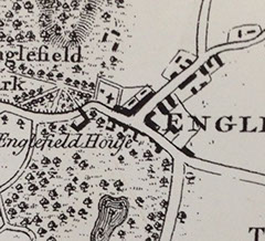
The earliest of these maps is John Roque’s road map of 1761 (left) and it shows the village centred around the cross roads that became known as Appleton’s Corner in the 19th century, with the buildings along the road that is now the private drive to Englefield House, between the church and what was then Green Lane running through Great Field.
What is now the deer park was then mostly farmland and there was even a house beside the long, broad, tree-lined avenue that stretched down from Englefield House. In the park nearer to Parker’s Corner was Cranemoor House, probably the home of the Englefields and Sir Edward Norreys, on the shore of the lake as it then was. In the area now occupied by the modern village, down as far as the junction where the old road to Tidmarsh diverged to the left, are more buildings, a few of which remain to this day.
Ballard's map of a year later shows shows things in closer detail with the dwellings outlined in red to distinguish them from other buildings. On the extract, right, they have been highlighted.
Running top to bottom is the road from Theale to Bradfield and left to right the road from Parker's Corner to Tidmarsh and North Street. At their junction is Appleton's Corner with George Appleton's house (though it wouldn't be that for another 100 years) in the north-west quadrant of the crossroads. Englefield House is in the top left corner.


Further down The Street around Chantry Farm where the road split, with the left fork going towards Tidmarsh and the right towards North Street, was another collection of houses. One of these, at this time owned by Thomas Horne, almost certainly was the original part of what became the school. Another part of Thomas Horne’s land was Horne’s Pightle, which is now the new school playing field. Another house, just beyond Chantry Lane, was the old Chantry Cottage on the site of which was built a replacement later in the 19th century.
Thomas Pride’s map of 1790 (left) shows a similar situation to Roque and Ballard 30 years before, though the Tidmarsh turnpike built by Powlett Wright in 1771 replaces Green Lane and the road across the park had been closed (but not removed as suggested here) with all the buildings, including Cranemoor House, apparently removed.
A building opposite the junction of the turnpike with the road to Theale might well be the original Three Daggers Inn for the location certainly accords with the description of the line of the turnpike. One hundred years earlier the village pound stood at this junction, opposite this building. It was later moved to the other end of the village, in the area where the old Tidmarsh road turned off The Street, where it remained until near the end of the 20th century.
Richard Benyon inherited Englefield in 1789, making it his permanent home in 1802, and apparently lost no time in removing the village and creating the new park. In fact, the road across what became the park in front of Englefield House was closed to public use as early as 1771 when Powlett Wright built the Tidmarsh turnpike and Thomas Pride’s map of 1790 (see page 6) does not show it (or Cranemoor House) at all although it still exists to this day as a private track. The building seen on this map opposite the junction of the turnpike and the road to Theale might well be the original Three Daggers Inn for the location certainly accords with the description of the line of the turnpike. One hundred years earlier the village pound stood in this area but it was later moved to the other end of the village, in the area where the Tidmarsh road turned off The Street (just past Chantry Farm in the image opposite), where it remained as a fenced enclosure outside “Elmfields” until near the end of the 20th century.