
The New Village
The Village in 1844
In 1843 there was a survey of the parish conducted for the ecclesiastical authorities in respect of rents and tithes for the church. A detailed map was accompanied by a listing of landowner, occupier and description of each house and numbered parcel of land. In the following year there was another similar survey of Englefield completed for Richard Benyon. Whereas the church survey is limited to the parish and the map is in black and white, Rochard Benyon's survey has the land belonging to the different farms and other owners colour-coded and also shows land just outside the parish boundary.
During the lengthy parliamentary enclosure process that started in 1809 and culminated in an Act of Parliament of 1829 the landowners were all compensated for their lost rights of common by being given freehold land in addition to that which they already owned. Then in a second phase some chose to sell all their land to Richard Benyon.
Despite this, in 1844 there was still some privately-owned land remaining, in fact most of it even within the central Englefield triangle, as shown by the extract from the ecclesiastical map below, with added colour.

The biggest portion (orange) was the Glebe land belonging to the Rector, then Edward Berens although Francis Eyre was acting as Vicar in the parish. The next largest area (blue) belonged to Caroline Hopkins and there were smaller portions held by George Appleton (green), including a house at the corner that stil bears his name, and John Price (pink).
Land around the outskirts of the parish was also held by others, including the Rector of Wallingford and Mrs Sophia Sheppard at Piper’s and Hogmoor. The John Hall’s Charity also had a considerable amount of the land on the south side of Common Hill.
Along the Pangbourne Road Wickcroft Farm (120 on the image above) was by now well established and tenanted by William Clarke.
The road to Bradfield still then followed its old course between the Pangbourne Road and Appleton’s Corner and the Rectory (88) was the one given by Richard Benyon as part of the enclosure settlement in 1829. The pair of cottages nearby (89) were occupied by Daniel Harris and George Swadling and there was a new lodge (128) built in the vee where the separate coach road to Englefield House, already there by 1829, leaves the Bradfield Road. This was occupied by Martha Horn.
At the top end of The Street (right) all the earlier buildings have gone except the house at the park gate (131), now owned and occupied by George Appleton which explains how Appleton’s Corner got its name. The new stables for Englefield House (75) are also shown and the old buildings on the other side of the road have gone.
The old Wimbleton farmhouse, is now three cottages (54) with the farm buildings just beyond.
Number 79 is the Crown Inn and owned by Caroline Hopkins along with the land seen earlier. All these parcels are occupied by “the widow Mildenhall”, a beer seller.
The gardens are shown in detail with their glasshouses (73) and also the new house for the head gardener, then William Greenshields, with behind it the bothy for the unmarried gardeners, at this time presided over by widow Betty Trinder, a 69-year-old “labourer” and also home to journeyman gardener Peter McPhail, like William Greenshields from Scotland, and apprentice gardener William Poffley.
Number 4 and 5 in The Street are shown at 72 and in the estate survey the occupier of number 5 is given as Charles Webb, who also occupied the shop (69) owned by Caroline Hopkins. The person actually living in number 5 was shoemaker Aaron Grey and the house was apparently also his shop. Number 10 in The Street is at 83 and occupied by Anne Pelham, a widow and a laundress.
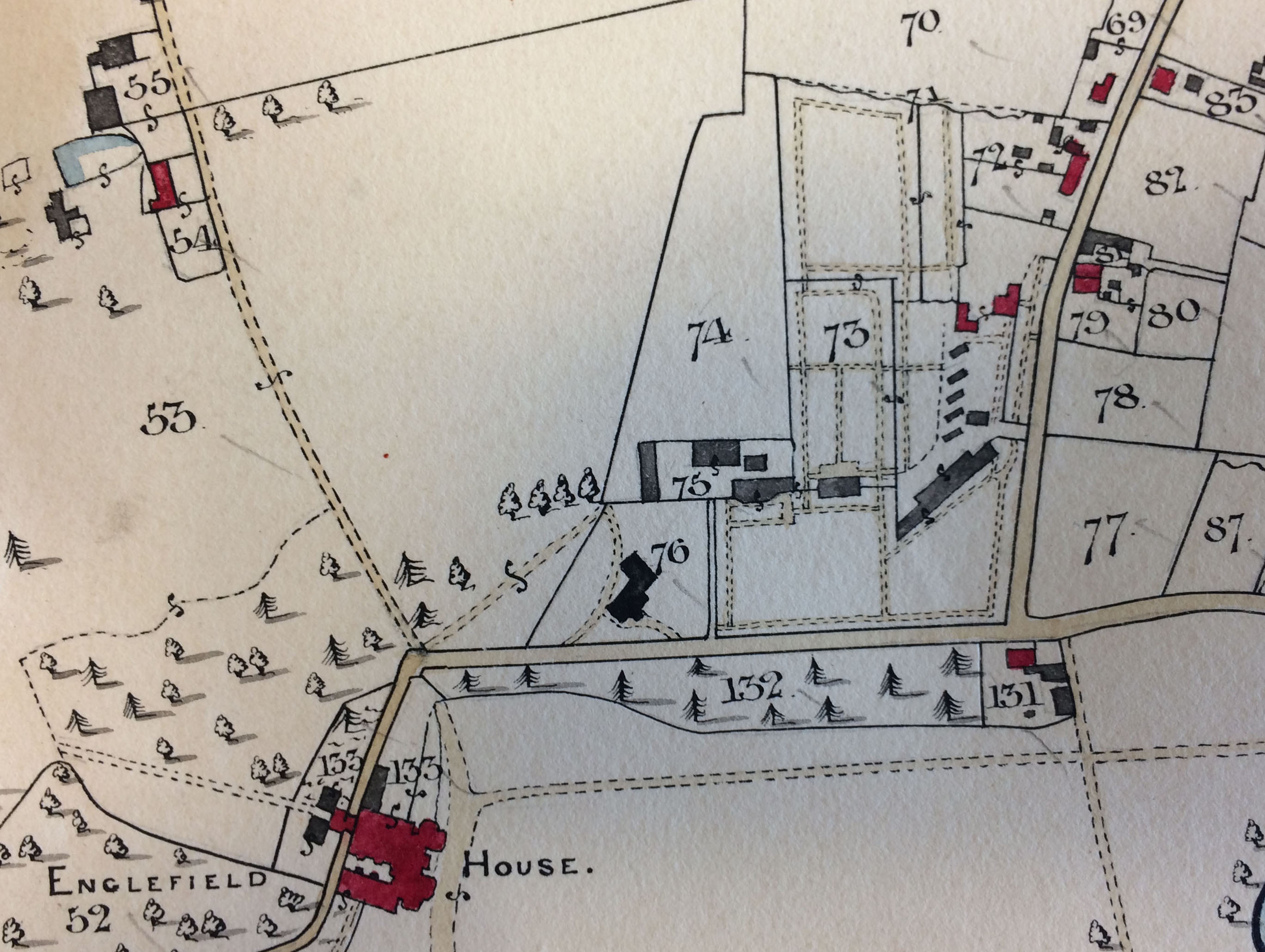
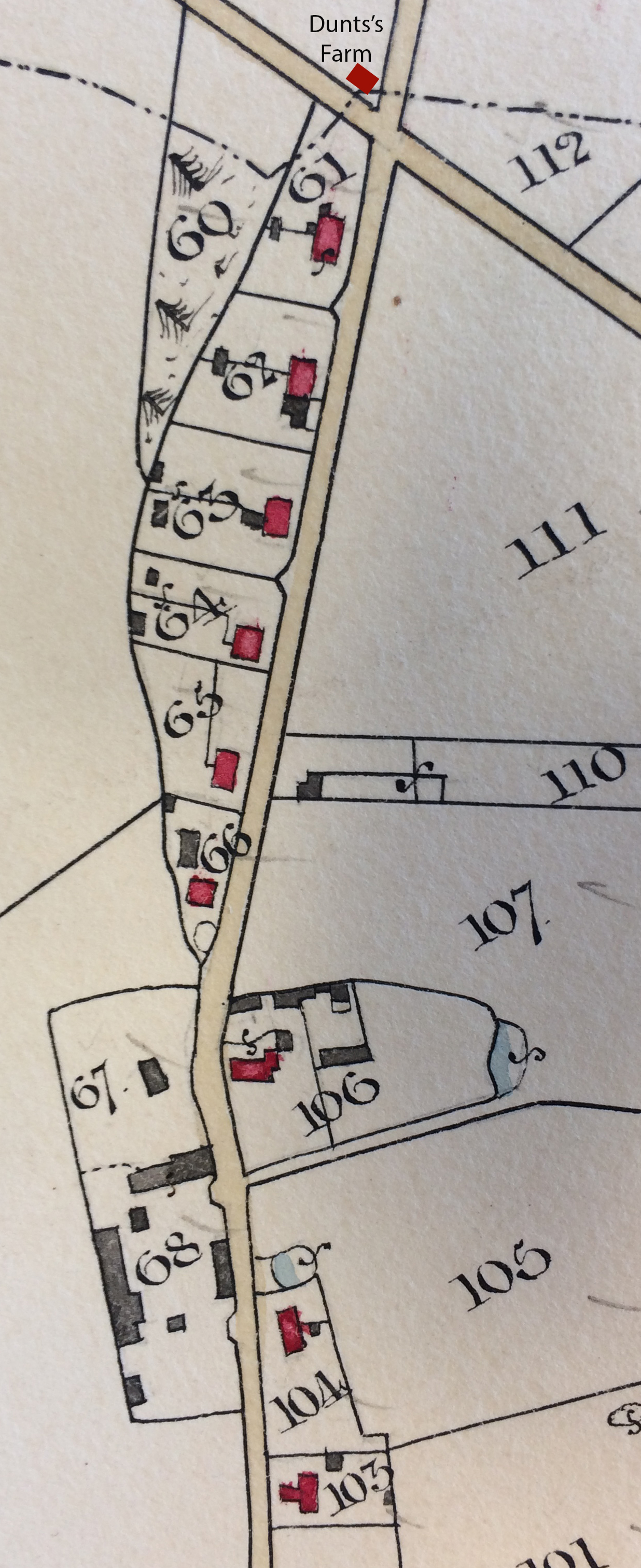
Continuing down The Street (left), the next house is the schoolhouse (103) occupied by schoolmistress Elizabeth Giles and her schoolteacher son Robert. Beyond that is the old pair of cottages (104) opposite the entrance to the timber yard (68) with “the widow Horn” and Charles Horn as the respective occupants. In 1851 Charles Horn’s daughter Elizabeth was an infant school teacher and according to Miss Winchcomb it was probably this building that was then the infant school and the schoolhouse was the senior school.
Just beyond Chantry Lane is Chantry Cottage (106), owned by John Price and occupied by Jesse Povey, seemingly as a sub-tenant of Richard Benyon.
At the top of the new, straight alignment of the Street (the original road round the back of these houses has now gone) at 66 is still the old Pound Cottage - not the pair that stand there today - occupied as noted on Richard Benyon’s map in about 1820 by Charles Mason, a builder, who also rents part of the Timber Yard (67).
Beyond Pound Cottage are now another two new pairs of cottages (64 and 65) in addition to the ones shown in 1820 (61 to 63) making the full complement of five, with the Three Daggers still at the end nearest the Pangbourne Road. At this time, with Kitty May as beer seller, the Daggers appears only to have occupied one of the pair of houses for Thomas Allen is shown as occupying the other. In 1851, the year after Kitty May died, when John Woods was the publican, the inn seems to have occupied the whole building, little enough space, for in addition to the public house Woods also had his wife, two sons, six daughters and a lodger living there.
On the other side of the Pangbourne Road is the former Dunts’s Farm now separated by the road from the rest of the village. This is now apparently two dwellings occupied by James Cox and James May but still the old farmhouse and not the building there today.