
Roads Around Englefield
The Road Over Common Hill
As soon as he took up permanent residence at Englefield after selling Gidea, Richard Benyon started on two projects. One was to create the new deer park in front of Englefield House and the other was to close the road to Bradfield that ran under the Long Gallery. Common to both of these projects was the creation of a new road from the Bath Road to the Bourne bridge and Bradfield, taking in the existing road up Blyth’s Hill.
The initial stage seems to have been confined to straightening Blyth's Hill. The undated plan, almost certainly earlier than 1802 and perhaps even from Powlett Wrighte's time, when he closed the road across the park after the turnpike was made in 1771 shows Blyth's Hill as it originally was with the intended modifications.
At the lower end of the hill is a pair of sharp bends, left then right: the original Parker's Corner. These were apparently intended to remain, presumably as they did not interfere with the planned new park. further up the hill was a sharper dog-leg right and left followed by a junction where it was necessary to turn right to continue up the hill. The course of the road that ran straight on at this point ran across the side of the hill into the piece of woodland known as “Great Dilhams”, then through a long grassy clearing in the woods called “Piper’s Green” to join the Beenham Lane just beyond “Plain Andrews” at the top of Mayridge Hill. Approaching the junction with the Beenham Lane was a long curve, also to the right, leading up to the T-junction. Both these bends formed incursions into what would become the new park.
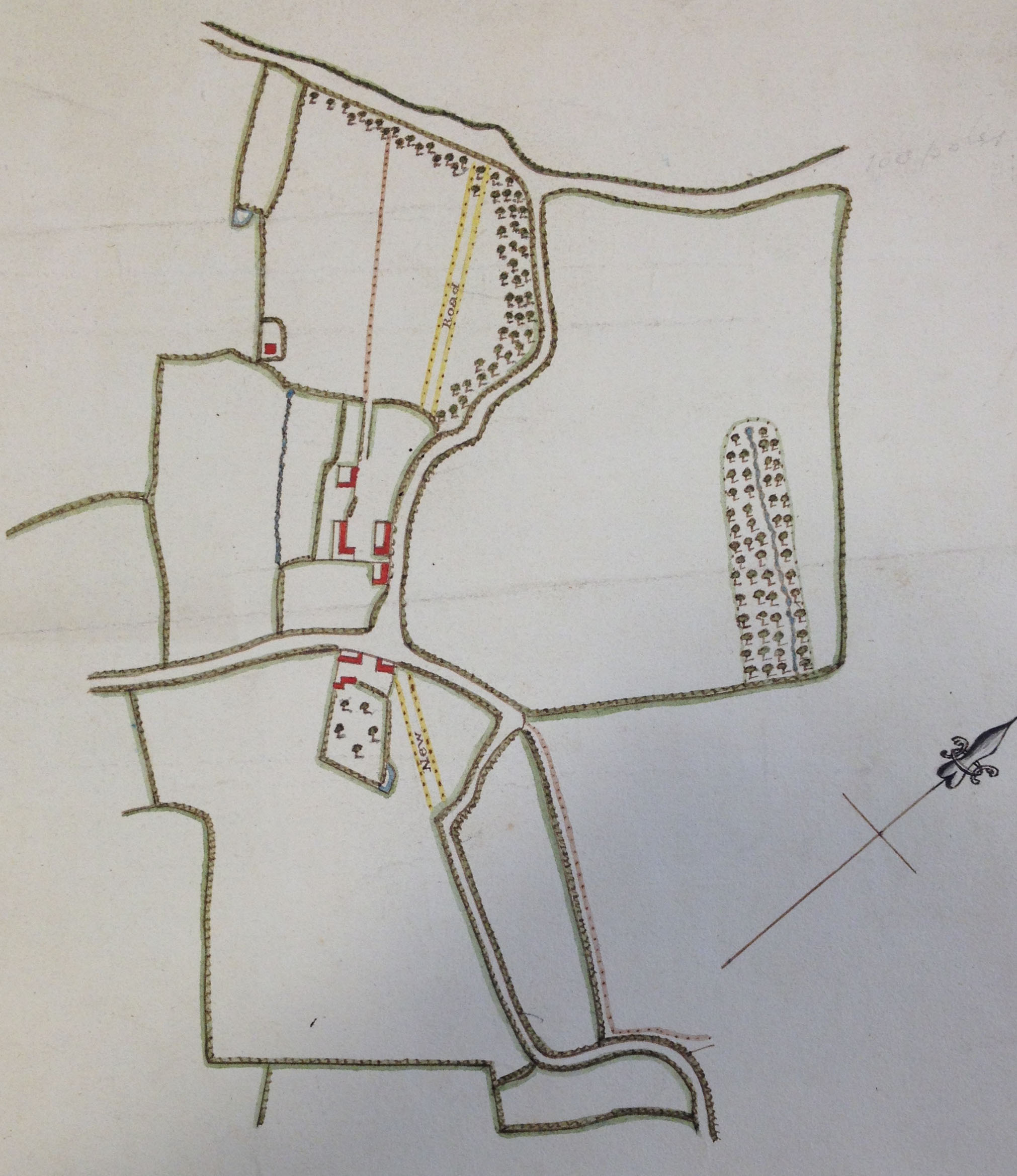
The plan for the straightening of Blyth's Hill
At the junction where the road up the hill turned off were some houses and there were more houses further up the hill - all these are shown in red. At least some of this land belonged to Mr Blyth and where the road ran into Dilham's was a pair of cottages, known as “Blyth’s Cottages”. These are not seen here but today the site can be identified by the small copse that stands at the end of a long bed of miscanthus.
Turning right after the dog-leg the road meandered towards the right as it approached the T-junction with the Beenham Lane, somewhat to the right of where it does today. Although the right-hand section of the Lane was stopped-up before 1829 the point at which it met Blyth's Hill can still be seen clearly. This upper part was obviously not intended to form part of the new park and the park wall does not actually extend this far, with modern chestnut railings fencing it in today. The wall does not start until the lower end of this section, level with the lower edge of the wood now covering Hill Close, where this particular section of road started.
The plan shows how these deviations were to be removed by two new straight pieces of road. Unfortunately, at least one of these pieces of road ran across land owned by Mr Blyth and after the alterations to remove the bends had taken place Richard Benyon wrote to him to apologise for inadvertently running the road over some of his land, mentioning that there was already a track there which the waggoners were in the habit of using when the weather was good anyway.
This whole length of road, from the bottom of Hill Close, at least, down to Parker's Corner was then edged with a wall in flint but there is a variation. The upper and lower parts have a coping of half-round brick but the section that covers the removed dog-leg has its coping in plain rectangular bricks, perhaps indicating that this setion was a later addition connecting the already existing walls on either side.
The second plan, which is dated 1802, shows a new section of road continuing beyond the Beenham Lane from Hill Close down the northern slope past the Englefield Common Wood (hence Common Hill) to meet the Bradfield Road coming from Englefield House just before the bridge over the Bourne. The proposed road seems to have run a little to the west of the present course to approach the “roundabout” on the Bradfield Road at a right angle rather than merging into the road as it later did. The section of the Beenham Lane between the old Bradfield Road and the top of Blyth’s Hill appears already to be stopped-up on this plan, although the new section of road replacing it (as shown in 1829) does not appear.
Either when it was actually built and certainly some time before 1829, Common Hill was realigned to its present course at the Bourne bridge end and two new pairs of cottages were built alongside it half way down the hill. The road into the common wood remained in 1844 and had also been extended to meet the road coming down from the top of Mayridge Hill. This road still remained connected to Common Hill in 1883 but the connection was severed sometime later, although the remainder of this road through the wood remains.
The plan also shows in pencil the double bend on Blyth’s Hill being smoothed to something like its present course. The route of the old road remains visible to this day.

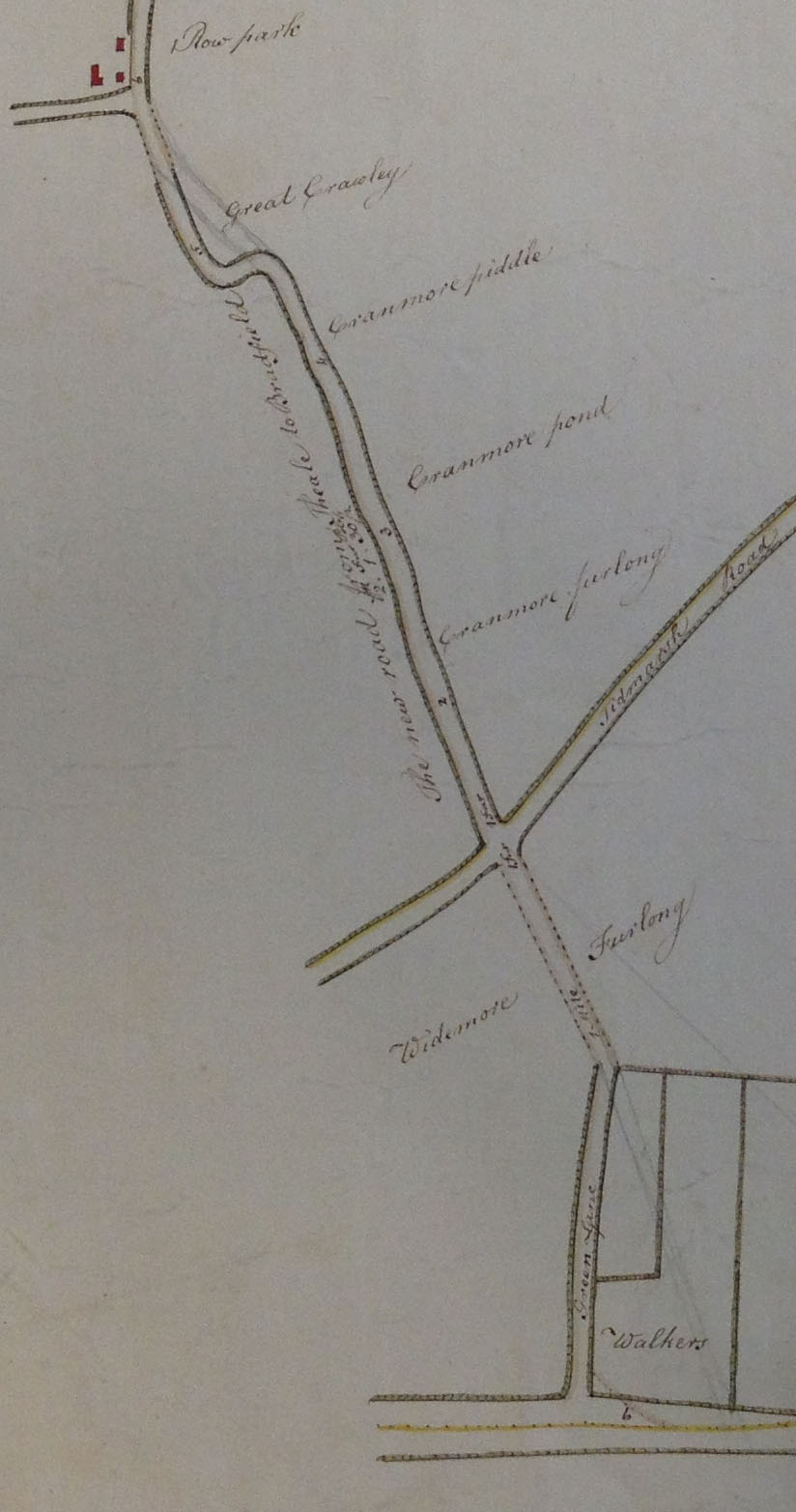
After crossing the turnpike the plan shows the new road running well to the west of Widemoor Wood then bending to the right to link up with the stub of Green Lane that remained after the road was closed when the Turnpike was built. Another pencil addition shows the road to continue straight at this bend, through an enclosure called “Walkers”, to join the Bath Road a little to the east of Green Lane. The First Series Ordnance Survey one-inch map of 1830 shows the straight road only but the enclosure map for the parish of Tilehurst in 1817, and that for Englefield in 1829 show both of these alignments, although the plan for the Pangbourne Road 1822 shows the Green Lane part only as a track.
An additional pencil line on the 1822 plan for the new Pangbourne Road shows Common Hill being diverted at its junction with the old turnpike to run alongside Widemoor Wood to join the Bath Road at the junction with Deadman’s Lane, as it does today. This change must have been partly adopted after 1829 but before 1844 for the tithe map of the latter year shows that after crossing the new Pangbourne Road the road remains straight for about half the distance to the Bath Road but then to turn sharply right along a field boundary to join the Bath Road at another point still to the west of Deadman’s Lane. At some time later, and certainly before 1883, the road was put on its present course to meet the Bath Road at Deadman’s Lane. Around the same time, at the other end of Deadman’s Lane, the North Street road junction was moved to its present position when the new Agency was built. The image shows Common Hill as it was by 1883 in yellow with the earlier versions of roads in light blue. In 1825 the turnpike was replaced by the Pangbourne Road and these are shown dashed to denote that they never existed together.
