
Roads Around Englefield
A difficulty with mapping the lines of ancient roads or other landscape features is that over time the traces may become disguised or even completely destroyed, not just by building but also by successive changes in agricultural practice. Even when left alone nature slowly covers any features and some World War 2 bomb craters that were clearly identifiable 60 or 70 years ago are now indistinguishable from natural landscape features. Furthermore many later roads can often mimic the appearance of old ones. Fortunately from the time King George III came to the throne things are clearer because then we start to get detailed maps that show local roads accurately. In 1761, the year before Josiah Ballard’s map, John Rocque produced “A Topographical Survey of the County of Berks” which, while not in such detail as Ballard's map, covers a wider area (below, left).

One of the remarkable things about the village of Englefield is the absence of through traffic, though terminating traffic is now pretty well continuous throughout the day. This was not always the case though, for the Englefield of the 1760s was very much in the main stream of traffic (such as it then was). The village in the 18th century was centred on the cross roads at Appleton’s Corner with buildings along the Theale-Bradfield road (now the private drive to Englefield House) between Green Lane and the church and along the road that is now the village street as far as where the road to Tidmarsh turned to the left off the road to North Street. There were also buildings in what is now the New Deer Park in front of Englefield House as can be seen in this map of 1765. These roads were then public through-routes and formed the principal connections between the Bath Road and the villages of Bradfield, Tidmarsh and beyond. Indeed the road from Theale to Bradfield formed part of the accepted "high route" between Reading and Newbury and was frequently used in winter as a better alternative to the Bath Road when wet weather made that very difficult going. Had this situation continued then Englefield would certainly not be what it is today.
The old manor house of the Englefield family was probably Cranemoor House on the edge of Cranemoor Pond then, as the map above from 1765 shows, on the edge of the village but when Englefield House was built in about 1590 it was set apart from the village, in the fashion of that time. Aside from that, Englefield seems to have escaped the Tudor craze for surrounding a great house with a spacious park, no doubt partly because of the disputed ownership after 1559, and it was not until much later that this process was begun, with Powlett Wrighte’s turnpike in 1771 - and even then it went relatively slowly.
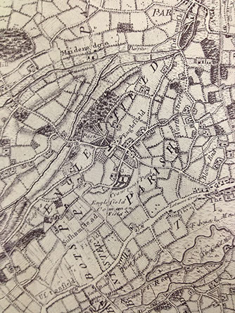
John Roque, A Topographical Survey of the County of Berks, 1761

Thomas Pride, A Topographical Map of the Town of Reading and the Country adjacent to an Extent of Ten Miles, 1790
Fortunately, the situation did not continue and the 30 year gap between these two maps we can see that Pride's map shows us the beginning of the creation of modern Englefield with the addition, in 1771, of the new turnpike from the Bath Road at Bostock along the edge of the modern Park to the existing road from Theale. This did little to remove traffic from the village but did at least make a start by enabling Wrighte to close the road across the Park in front of his house.
Richard Benyon de Beauvoir continued the road building with a view to closing up the road to Bradfield that then ran under the Long Gallery at the back of Englefield House. He first extended the road that ran from Parker’s Corner up the south side of Blyth’s Hill (nowadays Common Hill) in both directions to connect the Bath Road at Theale Green to Bradfield village. He next built another road (now the A340) from the Bath Road to Hogmoor Bridge and this enabled him to close Paulet Wrighte’s turnpike that ran through the village.
This still did not remove all through traffic, though, and that did not happen until, finally, New Road extended the road leading to Chalkpit Farm and the chalkpit on to Bradfield. This meant that there were now satisfactory alternatives for all journeys that previously had to pass through Englefield and the road past the back of Englefield House could finally be closed, though this was not achieved until the year after the death of Benyon de Beauvoir in 1854.
Crucially, all this occurred just in time so that the village itself now sits on an island of relative calm, unblighted by the huge increases in 20th century traffic.